The Phase 1B restoration section of the Stroudwater Canal is between Saul Junction, on the Gloucester & Sharpness Canal, and the new Ocean Railway Bridge in Stonehouse; a distance of about 6km (3.7 miles).
It is hoped that Phase 1B will be navigable by the end of 2028. (Source: Trow #206, pp 8)
The restoration is divided into three sections:
Section 1: Walk Bridge to the A38.
Section 2: The 'Missing Mile': A38 to John Robinson (Westfield) Lock.
Section 3: John Robinson Lock to the Ocean Railway Bridge.
The main elements of the restoration include:
- Reinstatement of 1.6km of canal and towpath between A38 and John Robinson Lock ('Missing Mile').
- M5 crossing.
- A38 roundabout crossing, including two new road bridges (completed in 2020).
- Moving utilities (pipes & fibre optic cables etc.).
- Reinstatement of three other bridges.
- Construction of two new locks.
- Construction of a new canal basin near the A38.
- Restoration and/or refurbishment of 6 locks.
- Re-routing of oil pipeline.
- Construction of Oldbury Brook culvert / aqueduct.
- Construction of a new railway bridge at Stonehouse (completed in 2022).
The following sections describe what is involved in more detail (some canal pounds are excluded).
Section 1: Walk Bridge to A38 (Whitminster)
Walk Bridge
Walk Bridge: This fixed low-level road bridge is the first major obstruction when travelling east from Saul Junction and will be replaced with a lift bridge, probably before the end of 2028 (Source: CCT AGM 22/11/2025.)
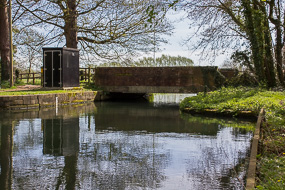
Whitminster Lock & Bridge
Whitminster Lock was partly restored by the Cotswold Canals Trust in the 1990s, but not gated. This lock will require some additional modifications for flood risk alleviation.
Under the proposed scheme the lock will be entered from the River Frome when travelling from Stroud to Saul Junction.
Whitminster Bridge is adjacent to Whitminster Lock this was once a farm access swing bridge, which is no longer operational. Public Right of Way EWH/21/3 crosses the canal here.
This will be replaced with a manually-operated lift bridge similar in design to Lodgemore Bridge in Stroud, except it will have two overhead balance arms, not one.
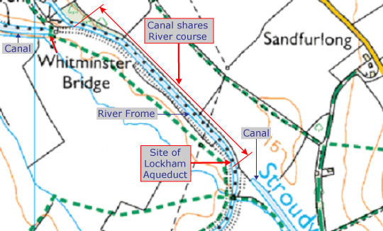
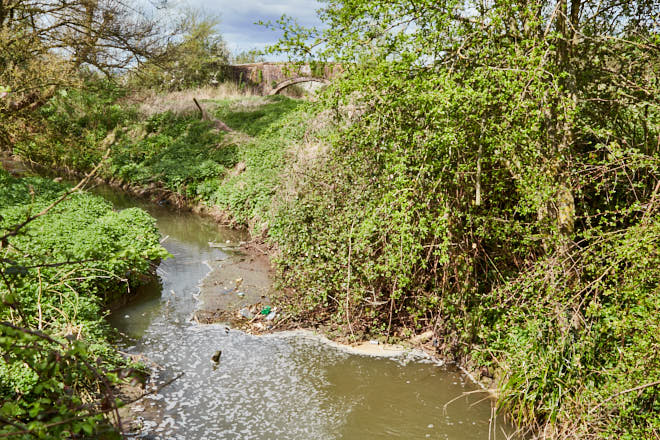
Canal and River Frome
For a distance of about 660m east of Whitminster Lock the canal line has been lost. It used to run parallel to the River Frome, but was infilled during flood prevention works.
Near where the canal reappears was Lockham Aqueduct (long since removed), which carried the Frome under the bed of the canal.
The restored canal will share the river course along this stretch, which was the case when the canal was built. (The canal was later separated to avoid it constantly silting-up.)
Stonepitts Lift Bridge
The original Stonepitts Bridge was a hump-backed farm bridge long since demolished. Public Right of Way EWH/21/3 crosses the canal here. This will be replaced with same bridge design as Whitminster, described above.
Oil Pipeline
An oil pipeline crosses the canal near Occupation Bridge which blocks the navigation. This is to be re-routed under the canal bed.
Occupation Bridge
Occupation Bridge carries a farm track over the canal and requires strengthening and general repairs.
Section 2: 'Missing Mile' - A38 to John Robinson (Westfield) Lock
The 'Missing Mile' was created when the M5 was built and a section of the canal was infilled and other structures demolished. The yellow items on the map below indicate where significant new structures are required, including a new canal channel using the River Frome M5 underpass.
The original route of the canal now bisects the large A38/A419 roundabout at Whitminster which is in the top left corner of the map below.
The planning application to excavate the Missing Mile was approved by Stroud District Council on 27 February 2024 (Source: Trow #204).
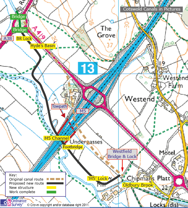
A38 Roundabout Crossing - Whitminster
This comprises two new road bridges and a canal channel on the A38 roundabout, which were constructed in 2020 by Gloucestershire County Council.
This removed one of the major route obstructions on this section of canal.
Replacement Bristol Road (BR) Lock
A new lock will be constructed to replace the original, which was adjacent to the former A38 bridge (demolished). The replacement lock will have less of a fall due to the insertion of another new lock east of the M5. This is required to lower the level of the canal under the motorway.
New Canal Channel A38 to M5
The original canal route between the A38 and Westfield Bridge/Lock is represented by the broken brown line on the above map.
A new channel will be cut along the approximate route indicated by the black line on the map.
Hydes Basin
A new canal basin and facilities will be constructed near the A38. Hyde's Basin takes its name from the nearby site of Hyde's Bridge on the Stroudwater which was demolished when the M5 was constructed.
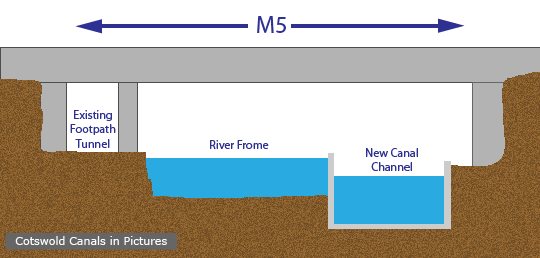
M5 Crossing
To prevent the huge expense and disruption of constructing a purpose-built canal bridge across the M5, the solution will use the existing River Frome underpass.
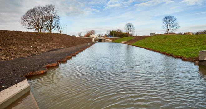
A new concrete canal channel will be added alongside the river. As will be seen from the illustration below, the level of the canal will be lower than the normal river level, to achieve the required headroom. As a consequence, during significant flood events the canal channel may be unusable.
It is hoped that the new channel will be complete by the end of 2027. (Source: CCT AGM 18/11/2023)
New Pedestrian Bridge
The existing footpath tunnel in the graphic above is not the towpath. The route the new towpath will take is between the river and canal when approaching the M5 from the east.
A new footbridge will carry the towpath over the canal just east of the M5 after which it will divert to use an existing underpass, a short distance to the north (see 'red route' on map above). This was originally constructed to allow cattle to pass under the motorway.
Once west of the motorway, the towpath will continue on the opposite bank until the A38, where it will cross back to join the existing route.
New 'M5' Lock
A new lock is required east of the M5 near John Robinson (Westfield) Lock to lower the level of the canal to provide sufficient headroom through the River Frome M5 underpass.
Westfield Bridge
Westfield Bridge is in fair condition and carries Public Right of Way EEA/37/2 over the canal. It will require some repairs.
Section 3: John Robinson Lock to Ocean Railway Bridge
It is a project aim to complete Section 3 of the Phase 1B restoration in 2025. (Source: Trow #204)
John Robinson (Westfield) Lock
Westfield Lock (its historical name), which had been infilled, suffered significant structural damage when the Oldbury Brook channel was constructed (see below).
Work started to excavate and repair the lock chamber in 2022.
Oldbury Brook
The Oldbury Brook originally flowed into the canal at Meadow Mi.l and flowed out again using the Meadow Mill spill weir, which discharges into the nearby River Frome.
After canal abandonment, a new deep channel for the Oldbury Brook was cut through the canal line at the tail of John Robinson (Westfield Lock), and the canal infilled on either side.
A new aqueduct will be constructed here to take the watercourse under the canal.
(buried Westfield Lock in between - before restoration started in 2022)
Dock Lock
Dock Lock has been partly restored previously, but has not been operational since canal abandonment. It requires further repairs, escape ladders, paddle gear and gates.
Pike Bridge
Pike Bridge was rebuilt in 2005 and it is assumed that this is maintained by Gloucestershire Highways.
Pike Lock
Pike Lock had been partly restored previously, but not operational since canal abandonment.
In common with Dock Lock it required further repairs, escape ladders, paddle gear and gates.
Repairs to the lock were completed in 2023 and it is now awaiting new gates.
Blunder Lock
Blunder Lock has been previously restored to operational condition, but will be fitted with new lock gates.
Newtown Lock
Newtown Lock has been previously restored to operational condition, but will be fitted with new lock gates.
Roving Bridge
Roving Bridge appears to be well maintained and carries a track over the canal.
Bonds Mill Bridge
Bond's Mill Bridge, once a swing bridge, was replaced in 1994 with an all-composite (plastic) hydraulically-operated lift bridge.
This is no longer operational and will be replaced with an electrically-operated lift bridge.
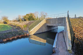
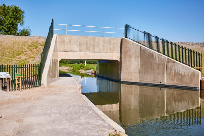
Ocean Railway Bridge
The most significant item in this section is the new railway bridge at Stonehouse. This was constructed by Network Rail at the end of December 2021.
Pictures of the bridge construction are here, with more information on the Ocean Bridge page.
Funding
In April 2018 Stroud District Council was awarded Round One Development Funding (about £0.8M) from the National Heritage Lottery Fund (NHLF). This was in response to an application submitted to the NHLF in November 2017 for about £8.9M towards the cost of Phase 1B, estimated at £20M (Source: Trow #204).
A successful final-round grant application was submitted to the NHLF in May 2020 which resulted in a funding award for £8.9M being announced in October 2020.
In addition to the NHLF, Phase 1B restoration is also being supported by:
- Stroud District Council (SDC) £2.3m.
- Gloucestershire County Council £700,000.
- Canal & River Trust (CRT) £625,000 plus additional support.
- Highways England £4m towards restoration of Missing Mile.
- Cotswold Canals Trust in the form of cash and volunteer resources.
Due to unavoidable project delays, and other external factors, the funding required to complete the whole of Phase 1B is now estimated at c£30M (Source: Trow #204).
Section 3 (The Ocean to John Robinson Lock) is fully funded, and work is underway.
However, Sections 1 and 2 are currently facing a £10M shortfall.
Cost reductions and additional funding sources are being progressed.